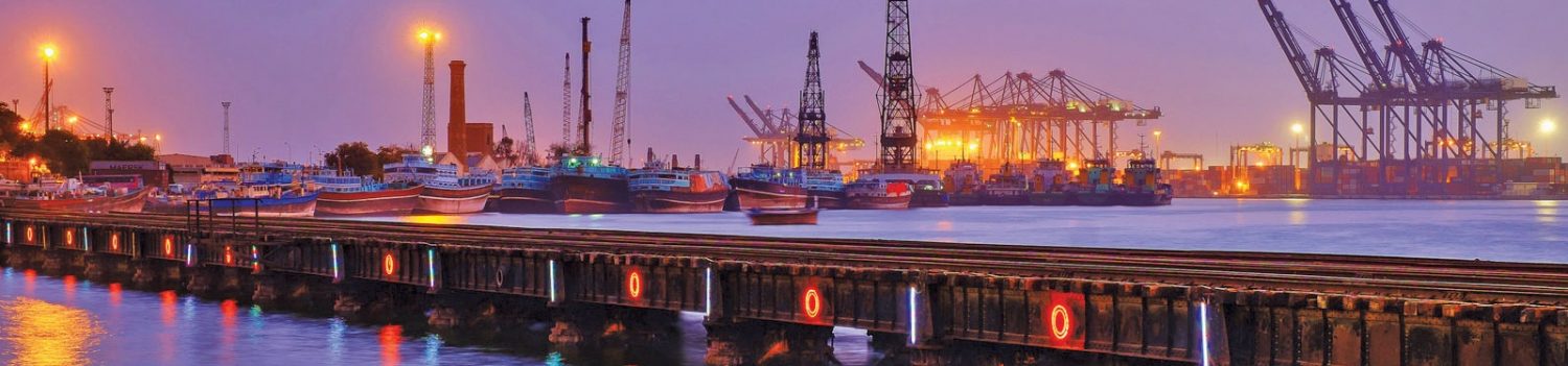
The area of Karachi (Urdu: تاريخ کراچی), in Sindh, Pakistan has a natural harbor and has been used as fishing port by local fisherman belonging to Sindhi and Baloch tribes since prehistory. The port was known to the ancient ancient Greeks by many names: Krokola, where Alexander the Great camped in Sindh to prepare a fleet for Babylonia after his campaign in the Indus valley; ‘Morontobara’ port (probably the modern Manora Island near the Karachi harbor), from where Alexander’s admiral Nearchus sailed for back home; and Barbarikon, a sea port of the Indo-Greek Bactrian kingdom. Karachi was called Ramya in some Greek texts.[1] The Arabs knew it as the port of Debal, from where Muhammad Bin Qasim led his conquering force into Sindh (the western corner of South Asia) in AD 712. According to the British historian Eliot, parts of district of Karachi and the island of Manora constituted the city of Debal.[citation needed] Lahari Bandar or Lari Bandar succeeded Debal as a major port of the Indus[2] it was located close to Bhambore, in modern Karachi.
According to legend, the city started as a fishing settlement, where a fisherwoman, Mai Kolachi, settled and started a family. The village that grew out of this settlement was known as Kolachi-jo-Goth (The Village of Kolachi in Sindhi). When Sindh started trading across the sea with Muscat and the Persian Gulf in the late 18th century, Karachi gained in importance; a small fort was constructed for its protection with a few cannons imported from Muscat. The fort had two main gateways: one facing the sea, known as Khara Dar (Brackish Gate) and the other facing the adjoining Lyari river, known as the Meetha Dar (Sweet Gate). The location of these gates corresponds to the present-day city localities of Khaaradar (Khārā Dar) and Meethadar (Mīṭhā Dar) respectively.
During the rule of the Mughal administrator of Sindh, Mirza Ghazi Beg the city was well fortified against Portuguese colonial incursions in Sindh. Debal and the Manora Island and was visited by Ottoman admiral Seydi Ali Reis and mentioned in his book Mir’ât ül Memâlik in 1554. In 1568 Debal was attacked by the Portuguese Admiral Fernão Mendes Pinto in an attempt to capture or destroy the Ottoman vessels anchored there. Fernão Mendes Pinto also claims that Sindhi Sailors joined the Ottoman Admiral Kurtoğlu Hızır Reis on his voyage to Aceh. Debal was also visited by the British travel writers such as Thomas Postans and Eliot, who is noted for his vivid account on the city of Thatta. During the reign of the Kalhora Dynasty the present city started life as a fishing settlement when a Sindhi Balochi fisher-woman called Mai Kolachi took up residence and started a family. The city was an integral part of the Talpur dynasty in 1720.
The name Karachee appears for the first time in a 1742 document of the Dutch East India Company, when a ship, the Ridderkerk, was shipwrecked along the coast nearby
Talpur Period (1795 – 1839)
In 1795, Kolachi-jo-Goth passed from the control of the Khan of Kalat, Kalat to the Talpur rulers of Sindh. The British, venturing and enterprising in South Asia opened a small factory here in September 1799, but it was closed down within a year because of disputes with the ruling Talpurs. However, this village by the mouth of the Indus river had caught the attention of the British East India Company, who, after sending a couple of exploratory missions to the area, conquered the town on February 3, 1839.[citation needed]
Company Rule (1839 – 1858)
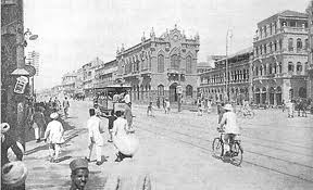
After sending a couple of exploratory missions to the area, the British East India Company conquered the town on February 3, 1839. The town was later annexed to the British Indian Empire when Sindh was conquered by Charles James Napier in Battle of Miani on February 17, 1843. Karachi was made the capital of Sindh in the 1840s. On Napier’s departure it was added along with the rest of Sindh to the Bombay Presidency, a move that caused considerable resentment among the native Sindhis. The British realised the importance of the city as a military cantonment and as a port for exporting the produce of the Indus River basin, and rapidly developed its harbour for shipping. The foundations of a city municipal government were laid down and infrastructure development was undertaken. New businesses started opening up and the population of the town began rising rapidly.
The arrival of troops of the Kumpany Bahadur in 1839 spawned the foundation of the new section, the military cantonment. The cantonment formed the basis of the ‘white’ city where the Indians were not allowed free access. The ‘white’ town was modeled after English industrial parent-cities where work and residential spaces were separated, as were residential from recreational places.
Karachi was divided into two major poles. The ‘black’ town in the northwest, now enlarged to accommodate the burgeoning Indian mercantile population, comprised the Old Town, Napier Market and Bunder, while the ‘white’ town in the southeast comprised the Staff lines, Frere Hall, Masonic lodge, Sindh Club, Governor House and the Collectors Kutchery [Law Court] /kəˈtʃɛri/[citation needed] located in the Civil Lines Quarter. Saddar bazaar area and Empress Market were used by the ‘white’ population, while the Serai Quarter served the needs of the ‘black’ town.
The village was later annexed to the British Indian Empire when the Sindh was conquered by Charles Napier in 1843. The capital of Sindh was shifted from Hyderabad to Karachi in the 1840s. This led to a turning point in the city’s history. In 1847, on Napier’s departure the entire Sindh was added to the Bombay Presidency. The post of the governor was abolished and that of the Chief Commissioner in Sindh established.
The British realized its importance as a military cantonment and a port for the produce of the Indus basin, and rapidly developed its harbor for shipping. The foundation of a city municipal committee was laid down by the Commissioner in Sinde, Bartle Frere and infrastructure development was undertaken. Consequently, new businesses started opening up and the population of the town started rising rapidly. Karachi quickly turned into a city, making true the famous quote by Napier who is known to have said: Would that I could come again to see you in your grandeur!
In 1857, the Indian Mutiny broke out in the South Asia and the 21st Native Infantry stationed in Karachi declared allegiance to rebels, joining their cause on 10 September 1857. Nevertheless, the British were able to quickly reassert control over Karachi and defeat the uprising. Karachi was known as Khurachee Scinde (i.e. Karachi, Sindh) during the early British colonial rule.
Pakistan’s capital (1947-1958)
District Karachi was chosen as the capital city of Pakistan and accommodated a huge influx of migrants and refugees from India to the newly formed country. As a consequence, the demographics of the city also changed drastically. However, it still maintained a great cultural diversity as its new inhabitants arrived from the different parts of the India. In 1958, the capital of Pakistan was shifted from Karachi to Islamabad and Karachi became the capital of Sindh. Large no. of rufugees migrated from India and embarked Karachi as the city of lights.
Cosmopolitan City (1958-1980)
This marked the start of a long period of decline in the city due to settlement of huge crowds of illegal refugees from other parts of the world. The city’s population continued to grow exceeding the capacity of its creaking infrastructure and increased the pressure on the city.
During the 1960s, Karachi was seen as an economic role model around the world. Many countries sought to emulate Pakistan’s economic planning strategy and one of them, South Korea, copied the city’s second “Five-Year Plan” and World Financial Centre in Seoul is designed and modeled after Karachi.
The 1970s saw major labour struggles in Karachi’s industrial estates, (see: Karachi labour unrest of 1972) During General Zia Ul Haq’s Martial Law, Karachi saw relative peace and prosperity, specially during the 3 years of Major General Mahmood Aslam Hayat, as Deputy Martial Law Administrator Karachi from 1977 to 1980
Post 1970s (1980-Present)
The 1980s and 90’s also saw an influx of illegal Afghan refugees from the Afghan war into Karachi, and the city now also called, a “city of illegal refugees”. Political tensions between the Muhajir and other groups also erupted and the city was wracked with political violence. The period from 1992 to 1994 is regarded as the bloodiest period in the history of the city, when the Army commenced its Operation Clean-up against the Mohajir Qaumi Movement.
Since the last couple of years however, most of these tensions have largely been quieted. Karachi continues to be an important financial and industrial centre for the Sindh and handles most of the overseas trade of Pakistan and the Central Asian countries.[citation needed] It accounts for a large portion of the GDP of Sindh, Pakistan and a large chunk of the country’s white collar workers. Karachi’s population has continued to grow and is estimated to have exceeded 15 million people. Currently, Karachi is a melting pot where people from all the different parts of Pakistan, Afghanistan, Bangladesh, Iran and India. The Sindh government is undertaking a massive upgrading of the city’s infrastructure which promises to again put this heart of Sindh city of Karachi into the lineup of one of the world’s greatest metropolitan cities.
The last census was held on 1998, the current estimated Population ratio of 2012 is :
Urdu: 41.52% Pashto: 18.96% Punjabi: 15.64% Sindhi: 10.34% Balochi: 06.34% Saraiki: 04.11% Others: 03.09%. The others include Konkani, Kuchhi, Gujarati, Dawoodi Bohra, Memon, Brahui, Makrani, Khowar, Burushaski, Arabic, Persian and Bengali.[84].[3]


